Disembark in S. Miguel and begin your visit in the largest city of the Azores, Ponta Delgada, where there is excellent accommodation able to ensure your stay includes every comfort and quality.Ponta Delgada, first settled by fishermen attracted by its safe port, soon began to take over as the island’s main port. It is now a dynamic and cosmopolitan city with a highly active outwardly looking cultural scene. The long road running round the port defines the city’s profile. Walk this coast road and experience its changing nature. Throughout the day, there is a constant stream of those going about their daily activities that, as the evening draws on, gives way, and especially in the summer months, to those of more recreational intent. This amply represents Ponta Delgada’s dynamism and adaptation to modern times while its accesses display the historical marks left by five centuries of history, precious testament to times gone by.


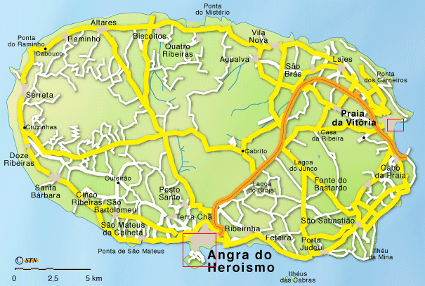
Terceira Island is an island in the Azores, in the middle of the North Atlantic Ocean, with an area of 396.75 km². The island's length is 29 km and the width is 18km; the perimeter is 90 km. Population is 54,996, down from a peak of 59,000. Population density is 140.73/km².
Terceira Island consists of four overlapping stratovolcanoes built above a fissure zone, which rise from a depth of over 1,500 metres (5,000 ft) on the floor of the Atlantic Ocean. The oldest at over 300,000 years is the Cinquo Picos stratovolcano that forms the eastern part of the island, with a 7 km (4 mi) diameter caldera which is one of the largest in the Azores. Next in age at perhaps 100,000 years is the Guilherme Moniz stratovolcano in the south-central part of the island, which also has a caldera with the highest remaining point on the rim reaching 623 metres (2,044 ft). Just to its north is the Pico Alto stratovolcano, probably less than 60,000 years old. It once had a caldera too, but subsequent eruptions filled it with several smaller lava domes and cones which top out at 808 m (2,651 ft).


The island of Santa Maria is an island located in the southeastern part of the Azores and is the southernmost island in the Azores Islands. It was the first island in the Azores Archipelago to be discovered. The discoverer of the island was Diogo Silves during his journey to Madeira in 1427. Gonçalo Velho brought families and cattle to the island.
The area of the island is 97.18 km². The island contains one municipality named Vila do Porto that has the oldest Azorean villages. The island also has old houses with windows that belonged to Capitão Donatário, dating back to the 15th century.
Due to its geological age (the island was formed 4.8 million years ago), Santa Maria is the only island in the Azores with an abundance of sediments. It is in these sediments that marine fossils have been discovered.
The houses are spread all across the island. Alentejana houses generally have large chimneys. The land is very fertile and the rural landscape has great beauty.


São Jorge also known in English as San Jorge) is an island in the central part of the Azores. It is separated from Pico Island by 15 km with a strait. Its east to west length is 53 km and its north to south width is 8 km. The area is 237.59 km² and the population is 10,500.
It was first discovered in 1439. The island wasn't populated until twenty years later when colonists came from the provinces of the northern part of Europe. São Jorge is a volcanic island, as are many of the Azorean islands. It has erupted six times between 1580 and 1907. Ten people were killed by the 1580 eruption and eight in 1808. In both eruptions small glowing clouds were reported. A possible submarine eruption was reported southwest of the island in 1964 but was not confirmed.
The highest point is Pico da Esperança at 1,053 meters. The island's agriculture includes cattle, cereals, and fruits. Other main industries include fisheries and dairy products.
Administratively, São Jorge is divided into two municipalities (concelhos), Calheta in the east with five parishes and Velas in the west with six parishes.


Faial Island also known in English as Fayal, is a Portuguese island of the Central group (Grupo Central) of the Azores. Its area is 173 km² and it is located 28.7° W longitude and 38.6° N latitude. The nearest island is Pico Island to the east. The island is also referred to as Ilha Azul (the "Blue Island"), by poet Raul Brandão, due to the large quantity of Hydrangeas that bloom during the summer months.
The original name of Faial (aka Fayal) was Insula de La Ventura (Venture Island) and it was possibly discovered by navigator Diogo de Silves, while in the service of the King of Portugal, in 1427. In 1432 a small group of Portuguese settlers came from Terceira Island to settle in the northern pasturelands of Cedros. Queen Isabela of Burgundy authorized the settlement of lands on the island. Flemish settlers under contract from the crown, and led by the nobleman Josse Van Huerter, came to shore at Praia de Almofariz (now Praia de Almoxarife) in the east of the island. A lack of potable fresh water resulted in a move to preceding valley, which today carries their name (Flamengos). According to the testimony of Henry the Navigator the island was then known as São Luís (Ilha de São Luís). By 1490, this Flemish community numbered approximately 1500 people. The Flemish joined with more Portuguese settlers and eventually formed Vila da Orta (later simply Horta). Some time later the island's name changed to "Fayal", due to the large number of Fayal trees [Myrica faya Aiton]. With the island's improving economy more Portuguese settled there and rapidly the Flemish influence diminished.


Island of Graciosa it has a surface area of 61 km2 and is the least humid island of the archipelago. It was given the nickname of the white island due to the delicate landscape and the names given to certain places including “Pedras Brancas” or White Stones, “Serra Branca” or White Mountainside, and “Barro Branco” or White Clay.The town of “Santa Cruz” is the seat of the only municipality on the island that bears the same name. In the town centre two water reservoirs are found. Although their original use was to provide water for the cows of the area they now reflect the tranquil crowns of the Brazilian pines and the elms surrounding them. This effect contributes to the already agreeable surroundings of the town centre. The architectural patrimony is demonstrated in the following structures:In the town of Santa Cruz, the “Igreja de Santa Cruz” (mother church), “Santo Cristo” Churches, and the “Nª Sª da Ajuda” (Our Lady of Charity), “São João” and “São Salvador” Chapels along with the “Cruz da Barra” (Iron Cross) and the Ethnographic Museum which contains items related to the culture of wine and the now defunct whaling industry, are definitely worth visiting;In Guadalupe, the Church of “Nossa Senhora de Guadalupe” (Our Lady of Guadalupe) is recommended followed by a visit to, “Nossa Senhora da Luz” (Our Lady of Light) in Luz and “São Mateus” in Praia


Pico Island is an island of the Azores noted for its eponymous volcano, Ponta de Pico, which is the highest mountain of Portugal and also the highest elevation of the Mid-Atlantic Ridge.
The main settlements are the capital Madalena, São Roque do Pico and Lajes do Pico, the total population is around 15,000.
The volcano is in the south-west of the island, at 38.47 N, 28.40 W. It is a basaltic stratovolcano 2,351 m high with steep sides. The last eruption on the island was in 1963, with a small submarine eruption off the northwest coast. Prior major eruptions were in 1562-64, 1718 and 1720. The paths of the lava flows are still visible, those of the 16th century and 1718 were particularly substantial, extending for over 10 km.
The island supported a substantial whaling industry until 1980. The position of the island on the Mid-Atlantic Ridge means that deep water is very close. Active industries include tourism, ship-building and wine production. Landscape of the Pico Island Vineyard Culture has been a UNESCO World Heritage Site since 2004. It has a notable wine, the Pico Wine.


Flores Island is an island of the Azores, a Portuguese archipelago in the Atlantic ocean. It has a surface of 143 square kilometers and a 2003 population of 3907 inhabitants.
Flores is divided into two municipalities (concelho), Santa Cruz das Flores in the north, with 1820 inhabitants, and Lajes das Flores in the south. The economy of the island is mainly agricultural, with yams and grain. Due to the early settlers being from northern Portugal, the island's houses and streets resemble those found there. Portugal has a military agreement with France permitting France to have a base in the region. The island also has an airport.


Corvo Island (Portuguese, Ilha do Corvo) is the smallest of and the northernmost of the Azores Islands and the northernmost in Macaronesia, being just 17.45 km² (6.75 sq mi) in area and having only 468 inhabitants (2006) living in a single municipality, of the same name, the smallest in Portugal and of the Azores.
The highest point in Corvo, to the south of the volcanic crater, is Morro dos Homens, at 718m (2,356ft). The entire island was formed by the collapse of a volcano, forming a caldeira. Known on the island as ‘Caldeirão’, the crater is 300m (984ft) deep and has a diameter of 2km (1¼ miles), and is often shrouded in mist.
The geography includes hills with forests to the east and rocky ledges to the west and north. The town itself is located in the southwestern part of the island
The geography includes hills with forests to the east and rocky ledges to the west and north. The town itself is located in the southwestern part of the island


Subscrever:
Mensagens (Atom)
